
Hermann’s time machine is a map.
An 1869 bird’s-eye view lets you explore a river town from a viewpoint its artist imagined.
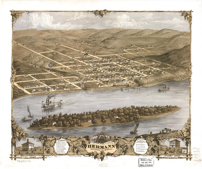
Start at the river. In A. Ruger’s 1869 view of Hermann, boats share the water while streets climb away from the bank. The town spreads across the hills in a careful arrangement of rooftops, roads, and green spaces. You can take in an entire place before choosing a single building to investigate. [1]
The Library of Congress identifies the image as a perspective map and specifically notes that it is not drawn to scale. That distinction is part of the fun. This is an artist’s constructed view, useful for noticing relationships and landmarks, rather than measuring the exact distance between two doorsteps. The lower border adds separate views of the market house and courthouse. [1]
Hermann’s German connection was intentional. Missouri State Parks traces the town’s origins to the German Settlement Society of Philadelphia and its effort to establish a community where German language and customs could continue. The map gives that larger migration story a setting you can inspect: a town of individual buildings, streets, and shared spaces. [2] [1]
Try treating the image as the beginning of a question. Which building draws your eye? What would you need to learn before calling it a school, workshop, or family home? An old picture can start a story beautifully. The next step is finding a record that helps answer it.
Explore Hermann in the atlas →
Follow the sources
- Bird’s eye view of the city of Hermann, Gasconade Co., Missouri, 1869Library of Congress, Geography and Map Division
- Historic Site History — DeutschheimMissouri State Parks
Sources reviewed September 13, 2026. Permanent link to this edition.